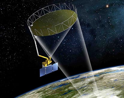
On Jan. 29, 2015, NASA will launch its Soil Moisture Active Passive (SMAP) instrument into space, where it can accurately measure Earth’s soil moisture levels via a mesh antenna of record-breaking size.
The instrument is comprised primarily of a radar, a radiometer, and the largest rotating mesh antenna ever launched into space. Once in action, SMAP will gather data that will help scientists predict Earth’s weather and crop yield, along with upcoming natural disasters like floods, droughts, and landslides. Though the water in Earth’s soil comprises merely a small fraction of Earth’s total moisture, it has a huge effect on agriculture and weather.
SMAP has both an “active” (meaning it emits its own signal) and a “passive” (meaning it records existing signals) remote sensor. This allows SMAP to garner highly-accurate, high-resolution measurements of Earth’s soil moisture levels.
To accomplish this, scientists at NASA’s Jet Propulsion Lab in Pasadena, Calif., built SMAP – the largest antenna that could fit into the required space of 1×4 ft, with a dish of 19.7 ft in diameter. This antenna allows SMAP to record data with a high degree of accuracy while traversing the globe every three or fewer days.
On one side, the antenna is attached to an arm with a crooked “elbow”; it rotates around this arm at around 14 revolutions per minute (also known as one complete rotation every four seconds). “We call it the spinning lasso,” Wendy Edelstein, SMAP instrument manager at JPL, said in a recent press release from NASA.
However, the size of the antenna proved challenging for the scientists; namely, it had to squeeze into an empty space about the size of a trash can during launch, while also being able to unfold with a great degree of exactitude, making the mesh’s surface shape accurate within just a few millimeters.
“The antenna caused us a lot of angst, no doubt about it,” Edelstein said.
The mesh dish, provided by Northrop Grumman Astro Aerospace, is ringed with lightweight graphite supports that stretch like an accordion at the behest of a single cable, which pulls the mesh outwards. “Making sure we don’t have snags, that the mesh doesn’t hang up on the supports and tear when it’s deploying — all of that requires very careful engineering,” Edelstein explained. “We test, and we test, and we test some more. We have a very stable and robust system now.”
The antenna, used by SMAP’s radar, transmits microwaves towards Earth in order to receive the backscatter signals that return. These microwaves penetrate only a couple inches into soil before bouncing back to SMAP’s antenna. SMAP can detect changes in soil moisture by detecting changes in the electrical properties of the microwaves it receives; additionally, by the same process, SMAP can tell whether soil is frozen solid. Using synthetic aperture radar processing, SMAP’s radar can generate high-quality images from 0.5-1.5 miles in resolution. In this way, SMAP’s radiometer is able to chart changes in Earth’s natural microwave emissions due to soil moisture.
However, NASA engineers had to contend with a significant problem – radio frequency interference. Specifically, the microwave wavelengths that SMAP traffics in are technically reserved for scientific use only, but other nearby signals – air traffic control, cell phones, etc – stray over onto SMAP’s wavelengths. To combat this problem, NASA engineers at Goddard Space Flight Center in Greenbelt, Md., designed and constructed a highly-complex signal-processing system for SMAP. Unlike typical signal processing, which averages data over an extended time period and thus renders itself vulnerable to being totally compromised by even the shortest bursts of interference, the Goddard scientists figured out a way to excise only the small spots of radio frequency interference. This leaves most of SMAP’s data intact.
By combining radar and radiometer signals, scientists can make the most out of the two technologies while minimizing their problems. “The radiometer provides more accurate soil moisture but a coarse resolution of about 40 kilometers [25 miles] across,” Eni Njoku, a research scientist working with SMAP at JPL, said. “With the radar, you can create very high resolution, but it’s less accurate. To get both an accurate and a high-resolution measurement, we process the two signals together.”
– Melanie Abeygunawardana
